壁紙を変更しました。
5年ぶりの変更です。
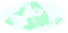
「世界の暦」が中心のサイトなので壁紙はずっと世界地図なのですが、今回は モルワイデ図法で地図の外周が太平洋とインド洋になるようなアングルを選ん でみました(☆アトランティス図法☆というらしいです)。
Mathematica で↓のようなコードを書いて作ったものです。
 << Miscellaneous`WorldPlot`

 shadefunc[country_] := Switch[country, _, Hue[0.4, 0.3, 1]]

 WorldPlot[{World, shadefunc},
  WorldRotation -> {70, 35, -60},
  WorldBackground -> Hue[0.5, 0.05, 1],
  WorldGrid -> None,
  WorldFrame -> None,
  WorldRange -> {{-90, 90}, {-180, 180}},
  WorldProjection -> Mollweide]
このアングルでみると「すべての大陸はほとんど地続きだ」ということが実感できます。
![]()